Protecting America's northernmost possession was a matter of national security in the early 1940s, and the task became especially critical after the Japanese bombed Pearl Harbor in December 1941. Alaska then became a potential enemy target. Without a land route between the Lower 48 states and Alaska, the U.S. military outposts in Fairbanks, Anchorage, and elsewhere in the territory were virtually stranded, dependent on supply deliveries by water and air, and vulnerable to attack.
In 1942, Ladd Air Field in Fairbanks became especially strategic to the Allies' defense plan. Ladd was the final U.S. destination for warplanes that were flown along the Northwest Staging Route from the continental United States to Fairbanks. Small airstrips along the way constituted a dot-to-dot route through the Canadian wilderness. Along this line, Lend-Lease Program pilots -- many of them women, who were not allowed to fly in combat -- ferried aircraft for delivery to Russian pilots waiting in Fairbanks. These pilots then continued the journey over the Bering Sea to Russia. All told, nearly 8,000 fighters, bombers, and cargo planes were flown along the Northwest Staging Route.
Clearly a road was needed, and in fact it had been considered as early as 1905, when Major Constantine of the North-West Mounted Police was charged to build a road to the Klondike but was later recalled from that effort. In the late 1920s and early 1930s, other proposed routes were examined and discarded. World War II was catalyst enough, and in March 1942, Canada and the United States came to terms on building the military road then known as the Alcan. Canada allowed rights-of-way and provided construction materials, while the U.S. military provided the manpower. It was agreed that the Canadian portion of the road would be turned over to Canada at the war's end.
When troop trains began pulling into Dawson Creek, B.C., a quiet hamlet boomed from a population of 600 to more than 10,000 by late March 1942.
Diaries recorded by the men who built the road portray an existence just as life-threatening as it might have been in battle. In the preliminary stage, workers felled trees to create a corduroy road, and the first bridges floated on pontoons. At Charlie Lake, three American soldiers drowned while crossing the lake on a pontoon barge.
That winter, the piercing cold was the enemy, along with the crude, temporary accommodations, bad food, and backbreaking, seven-days-a-week labor. Heavy equipment was sucked into the miry shoulders and sometimes abandoned. In below-zero temperatures, the big machines were kept running 24 hours a day, as they might not start again if allowed to cool. Trucks and bulldozers were pulled out of seemingly bottomless mud holes, and troop morale sagged with little contact from the outside world. In the summer, mosquitoes, no-see-ums, and black flies tortured the work crews.
Just as the American military had feared, Japan attacked and landed troops on U.S. soil in June 1942, briefly invading Alaska's Aleutian Islands at Kiska and Attu, and further heightening the sense of need for the road's completion. An ensuing battle at Kiska killed soldiers on both sides before Japanese troops retreated under cover of fog. Several Native Alaskans were taken from Attu to Japan as prisoners of war.
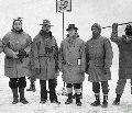
On September 25, 1942, the 35th Regiment of the U.S. Army Corps of Engineers, working from the south, met the soldiers of the 340th Regiment, working from the north, at a place named by the soldiers themselves: Contact Creek. The final link occurred a month later in Beaver Creek, Yukon Territory, when members of the 97th Engineers met the 18th Engineers and opened the road for military convoys to pass.
A photograph from that day shows two nose-to-nose bulldozers and two weary soldiers -- one African-American, one white -- shaking hands and smiling broadly for the camera. The official opening, along with a formal ribbon-cutting ceremony, came on a bitterly cold day, November 20, 1942, at what is now called Soldiers Summit at Kluane Lake, Mile 1061. Members of the Royal Canadian Mounted Police suffered in their dress uniforms at -35°F.
The Alcan would not be opened to civilian traffic until 1948, well after the war, and it remained a difficult journey suitable only for jeeps and specially-equipped vehicles for many years.
The Canadian Army took over jurisdiction of the Canadian portion of the road in 1946 and continued maintenance until 1964, when that responsibility was handed to the Federal Department of Public Works. Since 1971, the Yukon Department of Highways and Public Works has been in charge of the portion that passes through the Yukon Territory.
With the 50th anniversary celebration of the Alaska Highway in 1992, commemorative license plates were issued for those who drove the route. In preparation for the anniversary year, paved but damaged sections of the highway were repaired, and unpaved stretches were widened and improved. In the following 10-plus years, road crews have continued to work at upgrades in targeted sections, and today the only unpaved stretches are those that are undergoing a second round of stripping and repaving or widening. Vestiges of the old road are occasionally visible, especially where engineers have abandoned the wildly curvy route and blasted a straighter line through rocky barriers that confounded the hurried roadbuilders of the 1940s.
Tourism associations on both sides of the border joined forces to erect "historic mileposts," which in most cases do not match current milepost or kilometer-post numbers. That's because the highway is now shorter than it used to be, thanks to all of the straightening and rerouting improvements of the last six decades.
Significant historic sites include construction camps, airstrips of the Northwest Staging Route, the memorably steep Suicide Hill, memorial sites for those who lost their lives, and boundary lines marking the responsibility of various contractors. The Alaska Highway Interpretive Centre at Watson Lake, Yukon Territory, at Mile 613, offers exhibits on the building of the Alcan, including historic documents, photos, and displays of life in the work camps.
In 1996, the emergency wartime road that was built with remarkable speed received special recognition for the wonder that it is. The Alaska Highway was named an International Historical Engineering Landmark, joining the Eiffel Tower and the Panama Canal among the world's construction marvels.
Alaska Highway Facts
- Length of historic route to Fairbanks: 1,523 miles (2,451 km)
- U.S. troops used in construction: 11,000
- Civilian workers: 16,000
- Pieces of heavy equipment: 7,000
- Bridges constructed: 133
- Culverts installed: 8,000-plus
- Highest mountain pass: Summit, 4,250 feet, at Historic Mile 392
- Cost: $140 million
- Begun: March 1942
- Completed: October 1942
- Officially opened: November 20, 1942, at Soldiers Summit, Mile 1061
- Time: 8 months, 12 days
- Opened to the public: 1948
- Beginning, Mile 0: Dawson Creek, British Columbia
- Official end: Delta Junction, Alaska, Mile 1422
- Unofficial end: Fairbanks, Alaska, Historic Mile 1523
- During 50 years of road improvements, the road was shortened by 35 miles.
Excerpted with permission from The World-Famous Alaska Highway, 2nd Edition, by Tricia Brown © 2005, with permission of Alaska Northwest Books®, an imprint of Graphic Arts Center Publishing Company.
|
 |
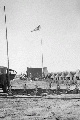 |
| U.S. Army construction camp for the Alaska Highway |
|
|
|
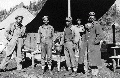 |
| Some of the soldiers who built the Alaska Highway |
|
|
|
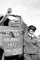 |
| Rusty Dow by truck, 1944 |
|
|
|
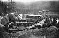 |
| Military bulldozer working on the Alaska Highway |
|
|
|
 |
| Group at the meeting of both ends of the Alaska Highway |
|
|
|
| Click here for all 18 photos in this gallery. |
|