|
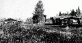
Ten years before the Klondike gold strike, discoveries in Alaska's Interior drew thousands of miners to area streams. Their claims were scattered throughout the area, yet their hub of commerce lay along the Yukon River: Circle City, it was named, the founders mistakenly believing they had settled on or at least near the Arctic Circle. The boomtown, which would gain fame as the "Paris of the North," was actually about 50 miles from the Arctic Circle. Nonetheless, in the years that followed, trails great and small sprouted among towns and mining camps in a transportation web from Circle City on the Yukon to Fairbanks on the Tanana.
Recognizing Alaska's need for improved transportation infrastructure, in 1905 the federal government created the Alaska Road Commission as a board of the U.S. War Department. The names of Alaska's highways can be traced to the military officers who served during those early years: Brig. Gen. Wilds P. Richardson, Maj. Malcolm Elliott, Capt. Glen E. Edgerton. Likewise, James G. Steese was a colonel who had been an engineer for the ARC and for the Alaska Railroad when Col. Frederick Mears, sitting president of the Road Commission, was ousted in 1923. Steese was appointed to replace him.
Completed in 1927, the highway between Circle and Fairbanks was named for Steese, an Army colonel who was later promoted to the rank of general in the Alaska National Guard. As with so many other Alaska roads, the Steese was mapped along a route long used by Native Alaskans and later by miners, freight haulers and mail carriers, who traveled by horse and dog team in winter months. The 162-mile highway crossed three summits and several rivers, an overland route that was a key link between the Yukon River steamship and freight-haulers who at last could reach the northern terminus of the Alaska Railroad in Fairbanks.
In 1932, the ARC was moved under the jurisdiction of the Department of the Interior. Another administrative move occurred in 1956, to the Commerce Department's Bureau of Public Roads. Finally, in 1960, a year after statehood, the Alaska State Department of Highways assumed oversight.
As Alaska Route 6, the Steese Highway today wends through miles so beautiful and rich with history that the 151-mile segment between Fox and Circle has been designated an Alaska Scenic Byway. Along the drive, motorists cross the Chatanika River, travel through the White Mountains, and gain access to Birch Creek, a national wild and scenic river. At Mile 86 is Twelvemile Summit, at 2,982 feet high. Further onward, the imposing Eagle Summit, at Mile 108, stands at 3,624 feet. From the Steese, travelers can hike the Pinnell Mountain Trail, explore the White Mountain National Recreation Area, or drive to the historic communities of Fox, Chatanika, Central and Circle Hot Springs.
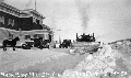
At Mile 57, travelers can see remnants of the Davidson Ditch, built in 1925. One of the largest engineering projects in the world at that time, the "Ditch" was actually a series of pipes and trenches crossing about 90 miles, a system ingeniously engineered to move water from the Chatanika River to gold dredges at Chatanika and Fox.
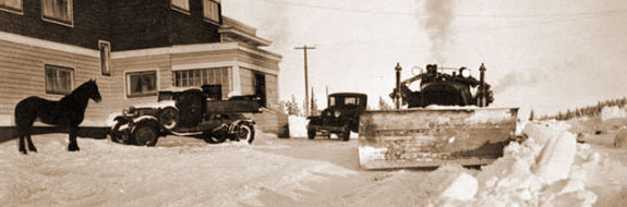
In a taped 1985 interview, Henry Woodrow "Woody" Johansen (1919-1991), a civil engineer who joined the Alaska Road Commission in 1955, spoke about the condition of the Steese Highway, and the dollars allocated for its maintenance. They were strongly determined by the price of gold, he said.
"No one knew what mining camp was going to become a permanent community," Johansen said. "And yet there was a need for transportation for that mining camp, and the result was that there were a good many roads built ... but then also, because a road was built, it didn't necessarily follow that that road was going to be maintained. It was built and maintained as long as there was a need for it, then it might have been ... I can think of several roads, for instance, all maintenance was pulled off them ... if there was then later a need established, that road was again maintained. A good example of that are many of the roads around Central and that mining community. All of the Steese. Many of those roads had no maintenance on them until 1975, then the price of gold went back up and people started mining again and the state started spending money again on maintenance."
Well maintained, but still no superhighway today, the Steese is paved for 44 miles, then turns to gravel. With a growing population depending on the Steese, it opened for year-round use in 1984. Travel in winter months requires checking ahead to ensure that any recent snowfall has been plowed. Road conditions year-round can be checked online at http://511.alaska.gov/ or through the Department of Transportation in Fairbanks at (907) 451-5204.
|
 |
|