|
Alaska and Canada's shared boundary, the longest undefended border in the world, was first established with the Anglo-Russian Treaty of 1825. At that time, Alaska was a possession of Imperial Russia and Canada was under British control. In the agreement, the demarcation was to begin near what is now Prince Rupert, British Columbia, at 54° 40' N latitude, just north of the mouth of the Portland Canal. From there, the boundary would follow the canal until it met 56° N latitude, then continue along the summits of the Coast Range to 141° W longitude. From that point, it was a straight line northward to the "Frozen Ocean."
Where the boundary followed the "crest of the mountains situated parallel to the coast," it was not to exceed the distance of 10 marine leagues inland from the ocean. The problem was, the authors of the treaty did not define "ocean" as it applies to the myriad channels and bays of the Inside Passage, nor did they indicate whether the distance of "10 marine leagues" should be measured from the heads of bays, or from the mouths of bays.
The fuzzy descriptors posed no great problem until well after the United States purchased Alaska from Russia. But the need for an exact boundary became more critical when gold strikes in southeastern Alaska and the Klondike made the real estate, as access to the gold fields, extremely valuable.
In January 1903, after five years of discussions, an international tribunal of three Americans and three British subjects settled the matter in favor of the American perspective, placing Haines, Dyea, Juneau, and Skagway on U.S. soil, along with the approaches to the Chilkoot, Chilkat, and White Passes. The Yukon would be a landlocked territory. Members of the tribunal included appointees of President Theodore Roosevelt: Senator Henry Cabot Lodge, Senator George Turner, and, hinting at Roosevelt's desire to "win," Secretary of War Elihu Root. Representing Canada were two lawyers, Sir Louis Jette and Allen B. Aylesworth. Britain's chief justice, Lord Richard E. Webster Alverstone, rounded out their party. Roosevelt influenced the final decision when he secretly divulged to the British representative that if the U.S. did not win the case, it might well declare war to achieve its means. In the end, Lord Alverstone voted with the Americans to avoid such a conflict against a British colony, enraging the two Canadians, who ultimately refused to sign the award.
Although the great Klondike rush had seen its peak by 1903, mining activity continued on both sides of the 141st meridian, and in 1906, both countries agreed to formally survey and mark that section of boundary, amounting to two-thirds of the border.
Crews labored for eight summers, working north and south from the Yukon River. They included surveyors, engineers, and astronomers with Canada's Department of the Interior and the U.S. Coast and Geodetic Survey. Slowly moving along the 141st meridian, they cut a 10-foot swath of trees and brush on each side of the boundary line and erected 191 monuments of concrete, granite, or steel set in concrete, each within visible distance from another.
In 1908, another formal treaty between the U.S. and Britain created the International Boundary Commission to mark the entire 1,538-mile border. In yet another treaty, in 1925, the two countries agreed to maintain the border markers and to keep the brush and trees cleared in the 20-foot swath. Today, the permanent IBC maintains about 9,000 land markers and lighted buoys along the boundary.
|
 |
 |
| The monument on the shore of the Arctic Ocean, 1,200 miles from the North Pole |
|
|
|
 |
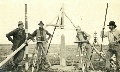
| Transit and heliograph at a main projection point |
|
|
|
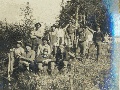 |
| Boundary survey crew |
|
|
|
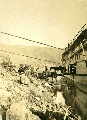 |
| "Unloading the Cayuses at the boundary" |
|
|
|
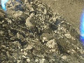 |
| Survey member and caribou |
|
|
|
| Click here for all 23 photos in this gallery. |
|